The district of Sibi was established in 1903 during British Rule its area was larger than the current district and lay between 27°55' and 30°38'N and 67°17' and 69°50'E lying south ofLoralai District, north of the Upper Sind Frontier District, west of Dera Ghazi Khan District and east of Kachhi, Bolan Pass and Quetta- Pishin. The total area of the district was 11,281 square miles (29,220 km2), but this included Marri Bugti county (7,129 square miles) which not directly administered by the British, leaving 4,152 square miles (10,750 km2) that were directly administered by the British [8] The population according to the 1901 census of India was 74,555 or 18 persons per square mile, the district contained four tehsils these were: 1n 1974 the district was subdivided to create Naseerabad and Kohlu districts, in 1983 Dera Bugti District, and in 1986 Ziarat District. Until 2000, except for Naseerabad, these new districts were part of Sibi Division of Pakistan. In 2000 the third-tier "divisions" structure of government was dissolved. In 1901 the total population was 34,974. 90% of the population were Muslims and 10% were Hindus.Now a day the majority of Sibi District consist of Balochs and Jamot that include Domki, Marri, Chandio, Silachi,Mandwani ,Rind ,Gorgage,Ghulam Bolak, Abro, Gola,Machi ,Bhangar, Mangrio, Kalhora and Soomro and minor population of pashtoon only in tehsil sibi, there are living in over villages namely khajjak, marghzani, luni, dephpal and some are migrated in sibi town this is factual position of sibi. Sibi District is Administratively Divided into two Sub Divisions i.e Sibi & Lehri. Sibi is on the western edge of Pakistan and is well connected with the country by a wide network of roads, railways and airways. Sibi Railway Station is junction railway station. The railway track was lined in 1890s during the British era to link Sibi with rest of the country. The routes are Sibi from linked with Lahore, Karachi, Peshawar, Rawalpindi, Quetta, Multan, Faisalabad, Hyderabad, Rohri, Sukkur,Bahawalpur, Dera Ghazi Khan, Kot Adu, Gujrat, Jacobabad, Gujranwala, Khanewal, Nawabshah, Attock, Jhelum, and Nowshera. Sibi is well connected by roads to the rest of the country. Sibi is connecting with Quetta, Karachi, Jacobabad, Sukkur and Hyderabad route. The district is administratively subdivided into two tehsils 14 union concils these are:[1]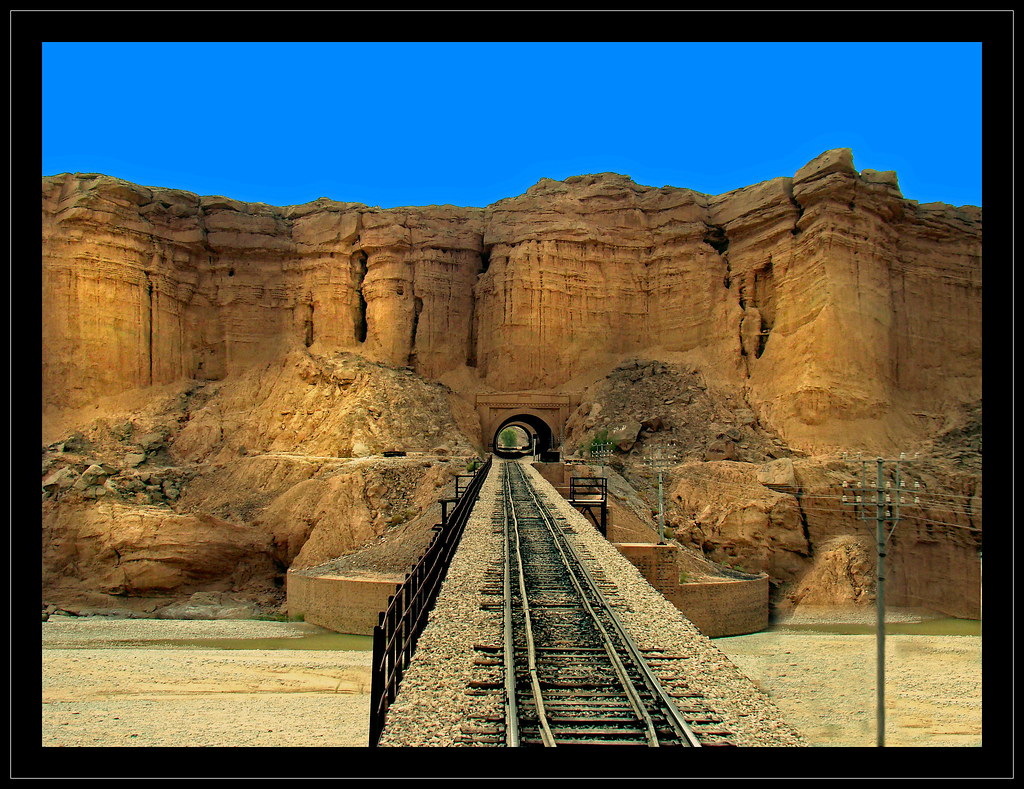
Sibi (Urdu: سبی) is a district in the Balochistan province of Pakistan.[1] The main mountains range are Zen, Bambore and Dungan. The climatic and topography of Sibi District is quite varied compared to other districts of Balochistan. It is also known as the "Hot spot" ofPakistan where the temperatures in the summer exceed far above normal over 50 °C. The district has two sub-divisions, Sibi and Harnai, which are further organized into tehsils and sub-tehsils: Sibi, Harnai, Kutmandi and Sangan.
Sibi District — District — 
Country Pakistan Province Balochistan Capital Sibi Established 1903 Government - District Nazim Mir Ali Murdan Khan Domki - District Naib Nazim Syed Muhammad Anwar Shah Area - Total 4,152 km2 (1,603.1 sq mi) Population (2005 Estimate) - Total 250,000 - Density 18.3/km2 (47.4/sq mi) Time zone PST (UTC+5) District Council Unknown seats Number ofTehsils 3 Website www.sibidistrictgovt.comSibi (Urdu: سبی) is a district in the Balochistan province of Pakistan.[1] The main mountains range are Zen, Bambore and Dungan. The climatic and topography of Sibi District is quite varied compared to other districts of Balochistan. It is also known as the "Hot spot" ofPakistan where the temperatures in the summer exceed far above normal over 50 °C. The district has two sub-divisions, Sibi and Harnai, which are further organized into tehsils and sub-tehsils: Sibi, Harnai, Kutmandi and Sangan. Until the end of the 15th century the district had been a dependency of Multan and had been part of Ghaznavid Empire ruled by petty chief named Nasiruddin Kubacha Around 1500 it was taken by Shah Beg of the Arghun Dynasty from Samma Dynasty of Sultan Of Sindh[2][3][4]and so came under the control of Kandahar. However during the period of Mughal rule the territory was once again ruled from Multan. In 1714 the territory was conquered by the Kalhoras ofSindh[5][6], but they were then displaced by the Durranis. During the rule of the Durranis the local governors were generally selected from the Barozai clan of the Panni Afghans.[7] In the 19th century it fell under Marris and Bugtis hand. To finish rebellion in the area, the Britishsigned the Treaty of Gandamak in 1879.
HistoryTahsil Area (sq mi) Population Kohlu 362 1,743 Sibi 1,343 20,526 Shahrig 1,595 16,573 Naseerabad 852 33,713 Total 4,152 74,555
Population
Transport
Railways
Roads
Administration[ed
SPONSORS

1 comments:
Very nice blog . I have also a large collection of Sibi district blog.
www.sibidistrict.blogspot.com
Post a Comment